Sunday, May 11, 2008

Pictured Rocks - May 2008

Check out the map of our trip on Trimble Outdoors: Pictured Rocks - May 2008 Trip


As most trips do, our trip started with planning. Sara and I had gone to Pictured Rocks last year, but we only got to hike about seven miles of the trail. This time we wanted to do a complete through-hike.


Last year our plans to spend the first night in a drive-in campground ended in disaster since we didn't arrive there until 0200 the day we were supposed to start hiking. This time we planned to drive from Detroit, and we reserved a hotel room for Sunday, May 4, 2008 to Monday, May 5, 2008. The place we stayed was pretty nice and offered a continental breakfast to let us fill up on calories before the long hike.


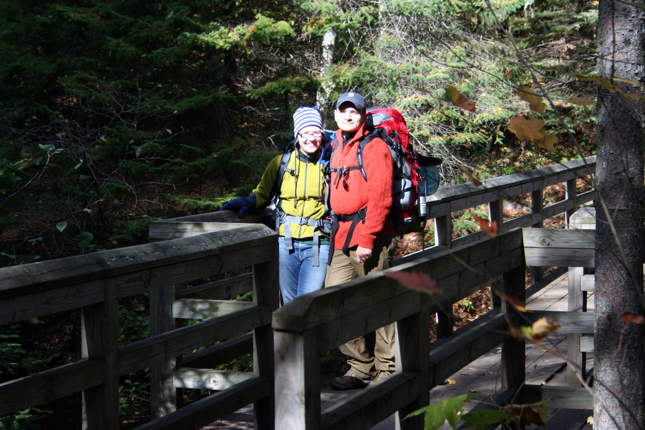
We got our packs all ready at the hotel Monday morning, ate our breakfast, and drove to the Pictured Rocks Interagency Visitor Center (400 East Munising Avenue, Munising, MI;  view in Google Maps). We got our back-country camping permits here, and told them we were going to stay at Sevenmille Campground and Mosquito Campground. Then we left and drove to the Munising Falls Interpretive Center (1505 Sand Point Road, Munising, MI; view in Google Maps)  to meet the ALTRAN shuttle. We had arranged for the shuttle to take us from the Interpretive Center to the northeast end of the trail at the Grand Sable Visitor Center (E21090 County Road H58, Grand Marais, MI; view in Google Maps) in Grand Marais. It cost us $75 for a pre-season trip, but it was worth it. The driver was very nice, and knowledgeable about the area.


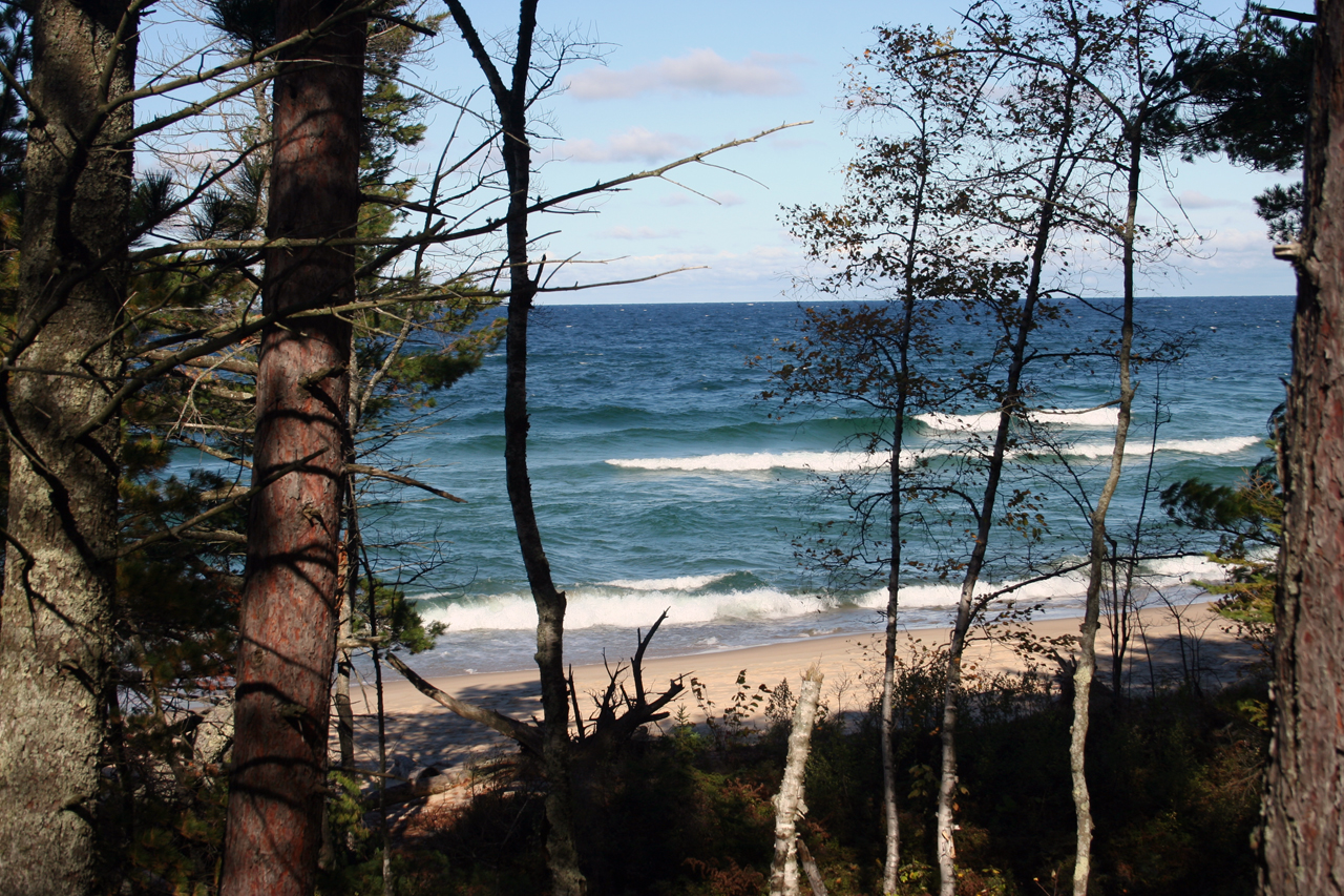
Once he dropped us off, we packed up, stretched, and started hiking. We headed south from the trailhead along a trail initially paved with woodchips. This soon entered a small wooded area, and the woodchips ended. Anice meadow came after the woods, then about a half-mile east through thin forest. We emerged from the forest to see the northern extent of Grand Sable Lake and followed its northeast shore along Highway 58 for a while. From there the trail headed east behind large sand-dunes to the north. Although we know Lake Superior was just over these dunes, we decided not to expend energy or time trying to climb them and focused on getting to Logslide. Logslide is a beautiful lookout over Lake Superior from atop steep sand dunes leading down to the water. There's a little bench where we took a break and ate a lunch of tuna and crackers.


Initially, going west from Logslide, the trail remained at the edge of the sand dunes, but this time we could see west, down the dunes, to the water. After the dunes, there was a long, relatively steep wooded descent. Lots of tree roots and wet leaves on the descent forced us to take our time. This led us to the Au Sable Lighthouse. The lighthouse was deserted at the time of year we came by. There was a picnic table and a drinking fountain, but the drinking fountain didn't work -- probably because it was the off season. By this point we'd already hiked 7.5 miles and Sara was starting to get tired.


The trail leading southwest from the lighthouse was a small, one-way dirt road. We could see to the beach from the trail, and we noticed the first of many wrecked ship carcasses.  Unfortunately, there's not much more left to see than a few beams sticking in an unnaturally ordered pattern out of the water. There was also an informational sign at the roadside that alerted us to the wreck and told its story.


The unimproved road led us to the Hurricane River campground, which spanned some distance along the shore. We took a short break on a bench here and saw a park ranger idling in his truck.  Sara was already having a tough time, and we considered asking the ranger to drive us out.  Sara decided to forge on, however, so we continued.  We also ran into a drive-in camper at his campsite and said hello. The hike from Hurricane River CG to Benchmark CG was primarily a foot trail in moderately dense forest.  It was rather uneventful and easy to follow. After Benchmark CG, we soon ran into the long, expansive, and sandy Twelvemile Campground. I wanted to mark this on my GPS, but I didn't know where the center was, so I marked the northeastern and southwestern extents.


The last three miles of the first day, from Twelvemile CG to Sevenmile CG were pretty rough, especially on Sara.  At some point earlier, she had pulled a muscle in her thigh, and she was forced to slow down. When we finally got to Sevenmile CG around 1900, we chose the first campsite we found northeast of the river. We set up camp near one of the fire pits and started a campfire. There was plenty of dry wood and birch bark around, which made it pretty easy. We roasted some bratwurst over the fire and ate dinner. This helped us rid our packs of the heaviest and most perishable food.  We then had time to go out and watch the beautiful sunset before falling asleep to the sound of the waves lapping up against the beach.  The next morning we ate fresh scrambled eggs which got rid of more heavy food.  Only light-weight dried food was now left to carry. We packed up and headed out by about 0900. Unfortunately, by this time Sara was sure she couldn't go all the way, so we decided to hike to Little Beaver Lake campground to see if anyone could drive us out.


Between Sevenmile Campground and Pine Bluff Campground, we had a difficult time staying on the trail.  It was pretty dense forest and there were many large downed trees that made us veer from the trail. At one point we went a few hundred yards off-trail before scouting in directions perpendicular to the general direction of the trail (toward the shore in a northwestern direction, then away from it in a south eastern direction).  This landed us back on the trail and made our progress easier.  Soon after we were back on it, the trail changed from a winding foot-trail to a straight, wide trail that made me think it had once been a road.  We traveled somewhat faster on this segment mostly because it was straight and generally free from fallen trees, but also because at the campground I had taken the majority of the weight in my pack, leaving Sara lighter and faster to keep up with me.


A few miles after Pine Bluff, we veered southeast along the trail to Little Beaver Lake Campground. Unfortunately, the plan didn't unfold as we'd hoped it would. We hiked a half-mile before I realized that we would be going a long way out of our way if we found no one at the campground to take us out.  So we doubled back on our track and changed our plan again. This time we decided to hike to Chapel or possibly even Mosquito campground, camp there for the night, and leave Sara at the campsite while I hiked to Miner's Castle to find a ride out.


The next few miles were rough for me because I was disappointed with myself that I hadn't realized that the Little Beaver Lake plan was a bad idea until we'd already wasted 20 minutes hiking toward it. It was also tough for me because I was carrying almost everything in my pack. I had to frequently take breaks to sit on a downed tree and rest my back and shoulders. During these breaks, Sara continued and I would hike faster to catch up with her, so our average speed wasn't reduced much. Once we reached Chapel Rock, we stopped for a break and took a bunch of pictures of the very scenic rock.


After leaving Chapel Rock, we quickly arrived at Chapel Beach. We rested at this beautiful beach for almost two hours to relax and take lunch. This was our best meal of the trip.  We ate home-made dried beanless chili that only needs boiling water for reconstitution. Sara found it on a blog for women hikers.  The recipe is here. She took a nap in the sun while I walked down the beach to Chapel Creek to refill two Nalgenes, rinse my smelly base-layers, and ice my feet.  Although the outside temperature was 65F, the water was very cold. Sara was in good spirits at this time, and despite her sore leg, she decided to soldier on for the last four miles to Mosquito.


When we got into camp, we chose the same site we picked last year, number five, primarily due to its proximity to the bear locker.  Bear lockers are so convenient, and this one was even more so because we were the only ones there.  We didn't have to worry about removing all the scented stuff from our packs and placing them in a bag to hang because both of our packs fit in the locker.  Anyway, we ate a terrible freeze-dried Pad Thai dinner, and we separated all the gear.  All the heavy stuff would stay with Sara at the camp site, and I'd only take my pack, my first-aid kit, my rain gear, and 3 liters of water.  On the way to the camp, we did run into two other groups who were both parked at the Mosquito/Chapel access lot. This lot is about a two mile hike from the Mosquito campground, and it's where I eventually ended up parking when I came back to pick up Sara. It would have been nice to get a ride out with one of the groups, but the first group was a large group of seventh and eighth graders with their chaperones hiking north on their way to the Coves campground. They planned to stay there overnight and weren't leaving until late the next day (5/7).  The other group was a group of older teens with their chaperones staying at the Mosquito Group site, but they too were not planning on leaving until the afternoon of the seventh. We wanted to leave earlier, so the plan was for me to wake up at 0300, pack up, and leave by 0400 to hopefully catch somebody along the trail to give me a ride back to my car in Munising Falls.


I left Mosquito in the dark of night by about 0345 Wednesday morning. Despite the blisters, the cold, and the pouring rain, I was able to make very good progress without Sara and with a lighter pack. It was a lonely hike though. Because I was hiking by headlamp, I couldn't see any of the beauty of the trail. Fortunately this was the segment of trail we had already hiked last year, so I just put my head down and plowed through. From what I remember, the segment from Mosquito to Potato Patch is a moderately dense deciduous forest with a well worn trail sometimes passing close to the cliff's edge. After Potato Patch, the trail goes down in elevation, past a large rock formation on the east side (a great place for lunch last year) to Miner's Beach.


The hike along Miner's Beach is very sandy and takes a little extra effort.  This was the first time I had any hint of dawn, and I could just barely see a difference between the pitch-black of the lake and the slightly lighter sky to my right. After the beach, the trail takes you over Miner's river and through the most picturesque pine forest imaginable. I only know this from last year's hike, however, because I flew through it at 3mph this year.  It was still dark, cold, rainy, and muddy.  I knew I was walking through beauty all around me but just couldn't see it.  After this forest is the climb back up what I like to call "Miner's Mountain" from the beach to Miner's Castle.  Once I got to the top I went right to the little rest-room shelter they have near the parking lot.  I skipped going out to see Miner's Castle because when I passed it, it was still dark, and I had already seen it the year before.  At the shelter, I ducked in for a while once I found a dry place to rest. I thought about staying there until someone drove up to visit Miner's Castle, but it was still only 0530, and I only had seven miles left, so I decided to leave after about 10 minutes. It sure was cold when I got back to the trail, but I warmed up quickly.


The trail from Miner's Castle to Cliffs was a somewhat dense deciduous forest.  The trail was very wet with lots of little streams and small wood bridges to cross them.  It was still early in the morning, so I didn't have very good light to see all the surroundings.


The final segment of the hike from Cliffs to Munising Falls had similar terrain to the wet forest near cliffs, but there were many beautiful waterfalls to see. I was trying to move fast, and I did fall once on a very slippery board-bridge. The last two miles were through a large network of Nordic ski trails. This involved a lot of elevation gain which really tired me out at the end of a 42 mile hike. I was really glad to finally see my car.  I ended up taking off my rain coat, rain pants, hiking pants, and hiking boots in the parking lot before driving back to pick up Sara. I put on my sandals and drove back in my soaked boxers and Cap 3 shirt. I turned the defroster on full blast, and still it could barely keep my windows dry.


I drove to the Chapel/Mosquito access parking lot and redressed. I hiked from the parking lot with an empty pack to the Mosquito campground, and surprised Sara because she wasn't expecting me for at least another 4-5 hours. We packed up all that was left at the camp site into both packs and hiked our last two miles back to the car. That made an extra four miles for me, but with half of it being no more than a walk in the woods (with essentially nothing on my back) it was easy.  After we left, Sara made up some more tuna and crackers to feed me while I drove.  We stopped at the Melstrand general store to pick up some candy bars. After three days of Clif bars and dried food in the back-country, those tasted SO GOOD. From there we headed back to Munising where I got a Z-pak for Sara's sinus infection, and we paid ten bucks for two showers at the Alger Falls Motel. We changed from our hiking clothes into comfy dry jeans and started the long trip home. All-in-all, it was a wonderful trip.


See prior posts for a listing of the gear we took.

Wednesday, April 30, 2008

Pictured Rocks Revisited. T-minus 5 days

We're planning another trip to Pictured Rocks, the place that inspired the creation of this blog. Although we look back at the last visit with fond memories of a cold night in the car stuck in the sand, we're not planning to repeat that adventure, specifically. Much more planning has gone into this trip, as has much more money for gear. I'll list that all down below.

We're actually going to Chicago first for three days because I have a conference. We'll fly out Friday, and when we fly back to Detroit on Sunday, we'll leave from the airport for the upper peninsula. I'm lucky to have the whole week off for vacation. Unfortunately Sara has to work 4 days straight starting next Thursday. That gives us from Sunday to Wednesday to hike the 42-mile trail.

We've already started preparations. I've got the itinerary all set out. This time, we're spending the first night (Sunday) in a hotel in Munising. Monday morning we'll go to the Munising Falls Interpretive Center to get our campsite permits when they open at 9:00 AM and catch the ALTRAN shuttle to Grand Marais at 9:30 AM. The shuttle normally runs from June 16 to September 30 for twenty bucks a head, so we had to arrange a special trip since we're going early. That'll cost an additional $35, but it's still cheaper than any cab service. I almost forgot to call to make the reservation. That could have been disasterous because they require pre-registration and pre-payment. Since ALTRAN doesn't accept credit cards, the check had to be in the mail today, which I was able to arrange despite being on-call in the hospital.

If all goes well, our shuttle will arrive in the Grand Sable visitor center on Monday around 11:00 AM. We'll get our gear all set and hike the first leg, 7.5 miles, to the Au Sable Light-house. We'll have a late lunch at around 3:30 PM, then hike another 7 miles to Seven Mile campground. We'll set up camp, eat dinner, and sleep. Tuesday morning, after breakfast and packing up, we'll set off on the 16-mile hike to Mosquito. The last leg will be 12 miles from Mosquito to the Munising Falls Interpretive Center, and after a few Motrins, we should be on our way home by around 3:30 PM.

We've also been busy getting food together. We're thinking of lugging some heavier food like marinated chicken breasts to grill over a campfire for Monday. The rest of the food is all home-made and dried with a Nesco food drier.

Recipes include home-made spaghetti for Tuesday night's dinner, with dried home-made sauce, dried beef, and dried noodles. I'm still working to perfect this one, but rehydration does take a full-boil, a few minutes simmer time, and about 10-15 minutes stand time. No-bean chili is for lunch Tuesday, with tuna and crackers for lunch on Monday and Wednesday. We'll allso pack in raw eggs to make scrambled eggs Tuesday morning. On Wednesday oatmeal will have to suffice. For snacks, I've cut up a whole pineapple, six small tangerines, four apples, and a grape-fruit and dried them. I also dried some lime wedges to drop in our camelbak for flavored water, admittedly an experiment, but one I hope will work well.

We've also been preparing ourselves. Last weekend we went on a 5-mile day-hike at Stony Creek, a local metro park, with full-weight packs. Sara's been working out 3-4 times per week. I went on a solo three-day, 36-mile hike on the Waterloo-Pinckney trail a few weeks ago when it was pretty frigid. I think we're physically much more ready than last time.

With regard to gear, we're taking the same Osprey Atmos and Aura back-packs and rain-covers. We added a second 3.0L CamelBak. We're leaving the old Sierra Design's Lightning tent behind in favor of a new REI Quarter Dome T2.

This will give us 2 doors, more head-room, and two vents for the same weight.

We'll take the same REI Lite Core 1.5 sleeping pads and REI Sub-Kilo sleeping bags, though Sara now has a Kilo-Plus which we'll throw in the car in case it's supposed to be really cold and she wants to carry the extra 11oz of insulation.


REI Kilo Plus -5 Sleeping Bag - Women's Regular

REI Sub Kilo +20 Sleeping Bag - Regular

REI Lite-Core 1.5 Self-Inflating Pad - Women's Regular

REI Lite-Core 1.5 Self-Inflating Pad - Regular


We both picked up new boots. My Merrell Pulse II's gave me awful toe-bang on the Waterloo-Pinckney trail, so I picked up a pair of Asolo Fugitive GTX boots on sale. Sara bought a pair of North Face boots at an outlet; I hope those do okay for her because they made her toes numb in Colorado and caused a lot of blisters on the 5-mile Stony Creek hike.


We both bought full rain gear (Arc'teryx Beta SL jacket with REI Ultralight pants for me, and Marmot Precip jacket with Arc'teryx Alpha SL pants for her). We tried to pick up matching sets of rain-gear, but you get what you can when sniping for low prices on eBay.


Arc'Teryx Beta SL Rain Jacket - Men's

REI Ultra Light Pants


Marmot PreCip Rain Jacket - Women's

Arc'Teryx Alpha SL Rain Pants - Women's


Otherwise, I'll be taking along the trusty wool sweater for insulation and Sara's got a new 800-fill Patagonia Down Sweater Vest.


We both picked up a pair of The North Face Paramount Convertible Pants and we'll bring along the same REI MTS long-underwear. I'll bring my Patagonia Capilene 3 Zip-Neck Top in case I need another layer. Sara may bring an REI or Columbia fleece too. We're leaving the heavy parkas behind this time, but we'll each bring a pair of light gloves. We're taking the same First Need Deluxe water purifier and Primus Eta-Power stove, although we've added a smaller 1.7-liter pot to it. This time there will be no "Wanda," as we'll know where we're going and verify our position with a Garmin GPSMap 60CSx. Other standards include LED headlights for both of us, matches, first-aid kits, and other routine stuff. Oh, we'll also take a much smaller camera this time, rather than the digital SLR we borrowed last time!

All in all, we're more experienced, more prepared, lighter, and leaner this time out. I think it will be a great trip, and I can't wait to get back out on the trail.

-M

Wednesday, January 9, 2008

Colorado Trip

I'm writing this entry from a mountain-view chalet at the Steamboat resort. I had vacation from Jan 6-12, and Sara doesn't start work until Jan 14, so we decided to come out and visit my brother, Eric, in Denver for the week. Eric moved to Denver over two years ago, and he took the week off work to ski with us.

We arrived at Denver International Airport on Saturday, Jan 5, and spent the first night getting all settled in. We also went to the 5:00 PM Mass at Eric's local church to free up Sunday for skiing. We had planned on driving into the mountains for our first day of skiing, but I-70 was closed so we just went hiking instead. Eric and his girlfriend Maria guided us through some areas of the Red Rocks amphitheater just outside of Denver. After this we drove up to Boulder and walked through the town, stopping at BJ's for dinner.

That night we bought tickets for Arapahoe Basin, but again I-70 wasn't open Monday morning so we chose to ski at Winter Park instead. This turned out to be an enjoyable, though expensive alternative, with lift tickets at $85 per person.

We rented this chalet at Steamboat for Tuesday and Wednesday nights, so Tuesday morning we left Denver for Steamboat Springs, stopping at REI on the way to pick up rental nordic skis. We stopped at Rabbit Ears Pass on the way up to Steamboat Springs for a little back-country cross-country skiing. The Walton area was absolutely beautiful, though poorly marked. We tried to ski the 3A loop by staying in others' tracks, but ended up turning back after an hour or so because we weren't sure we were still on the 3A trail.

After driving the rest of the way to Steamboat Springs and unloading into our chalet, we went downtown to the Tap House bar on Lincoln & 7th to watch the Wings vs. Avs game. The next morning we headed out to Steamboat for another perfect day of downhill. The weather could have been better -- 12" of snow fell during the course of the day, and there was no sun at all -- but we still had a great time. After we'd put in a full day on the slopes, we ate a quick dinner and headed out to the Strawberry Park hotsprings for a relaxing soak in the mineral water. This was quite an experience -- after a long 2-mile drive through steep, curvy, snow-covered dirt road we reached a small cabin where we paid our admission of $10/person. From there we walked a little further down the road to a dark stairway, leading to the springs. There were no lights anywhere, and I really wish I'd brought my head-light. Although the temperature was only about 20 F and I was only wearing sweat pants over my bathing suit and a wool sweater, I wasn't too cold. Not until I shed everything but my swim trunks, at least. But I was soon basking in the 144 F mineral water, taking the nip out of the cold air above. I should note that this area was "clothing-optional after dark," but no one was using flash lights in the water, so if anyone was nude, I couldn't tell. Surprisingly, after an hour of bathing, leaving the water and changing out of my bathing suit did not feel terribly cold. There was a certain lasting warmth that the water imparted that kept me warm long after I left it. We changed outside right next to the hot springs since there was no locker room or other facility to change in. But again, it was very dark so nobody was very worried about exposing himself.

We drove home, we all showered to remove the faint smell of sulfur in our hair, and everyone else went to bed. I decided to write for a bit first, and here I am... Our plans for tomorrow are to get up early and go back to Rabbit Ears pass for more XC skiing. This time I downloaded a topographic map with the different trails on it and re-drew the trails on Garmin MapSource so I can tell roughly where I'm going using my GPSMap 60csx. After sking one or two of the loops, we'll head back, pack up, and drive back to Denver. Right now, CDOT is still stating that I-70 is closed at the Eisenhower tunnel, so we may have to take US-40 back the whole way. I've never gone this route, but from the maps it looks harrowing...

Well, that's it for now. I'll add pictures, pdf maps, and gpx files soon!

Saturday, October 13, 2007

Pictured Rocks National Lakeshore Part 3 - Lessons Learned, Gear, and Files

Lessons Learned

  1. Don't trust mapping programs. They are a helpful utility, but always review a good old-fashioned paper map first to make sure they're not leading you down a treacherous 12-ft wide dirt road when you could be on a paved four-lane highway.
  2. Use appropriate zoom level with GPS devices. Given the size of the earth, GPS is amazingly accurate. Even if it could pin-point your position down to a few inches, however, when a mapping program is zoomed out, it is difficult to tell your exact location with regard to your route.
  3. Research campsites ahead of time. Carrying a 2 lbs. 9 oz, 9x9x13 inch bear canister to a camp-site with both a bear locker and a bear pole was a painful mistake.
  4. Pack a sheet of paper with standard volumetric unit conversions on it to aid accurate measurment when cooking.
  5. Try not to backtrack. We hiked 14 miles, but only saw 7 miles worth of scenery. Shuttle services take hikers from one end of pictured rocks to another for a small fee.


Gear

Packs: I carried the Osprey Atmos 65, and Sara carried the women's counterpart, the Osprey Aura 65. We both found the packs roomy enough for a cool weekend hike, but we also both noticed the shoulder straps lacked sufficient padding. These are great packs for the price, however. We both had a REI Duck's Back Rain Cover for 60L packs in case it rained. These easily fit over our packs. I had a CamelBak OMEGA Hydration 70 oz Reservoir in my pack from which we both drank.

Tent: Sierra Designs Lightning 2-person, 3-season tent. This is a standard tent with rain-fly. It goes up without hassle, and it does its job well. It was a little cramped with the two of us and all our gear, but we could have left the gear outside under the rain-fly.

Sleeping bags: I used the REI Sub Kilo +20 down bag, and Sara used the women's equivalent REI Sub Kilo +15 down bag. They pack very small -- about the size of a football -- and are very light. I found my bag to provide plenty of insulation. Sara, however, was very cold in hers. We both used Sea To Summit Ultra-Sil Medium 11 x 18 Dry Sacks to keep our sleeping bags dry in case of rain or unintended contact with water. These were great dry sack, and I could fit a few pair of extra socks and some other clothes along with my sleeping bag.

Sleeping pads: We both used the REI Lite Core 1.5 Self Inflating Pads, though Sara again used the women's version. Mine did well to keep me insulated from the cold ground. Sara was cold, but she slept on her side, possibly compromising the pad's ability to keep her off the ground. They both pack down to very small sizes, and they're both quite light.

Footwear: My hiking boots are Merrell Pulse II's. They kept me warm and dry, though I did have a few blisters on my heels after hiking 14 miles. Sara wore old cross-trainers that were comfortable, but cold. She has since bought proper hiking boots.

Base-layer: We both wore REI MTS Lightweight underwear, and we both liked it a lot. It has 0% cotton, so it doesn't get damp. It also is stretchy, snug, and warm. I'm considering a set of the mid-weight underwear for colder pursuits this winter.
Men's half-zip top, Men's bottom, Women's half-zip top, Women's bottom

Pants: I wore Columbia nylon pants; Sara wore jeans. I'm glad it didn't rain.

Layering: I just wore a zip-neck wool sweater, which kept me warm most of the trip. Sara had an REI fleece, though I'm not sure of the model.

Coat: We both had waterproof Columbia Titanium coats with removable fleece liners. Neither of us wore them except for at the camp-site when we were making dinner. Otherwise we packed them. I'm glad we brought them, however, because dinner would have been very cold in just a sweater.

Accessories: Sara wore a wool/fleece winter hat. I wore a baseball cap but brought an REI Taku Sombrero in case it rained, but ended up not needing it.

Water purification: We took one First Need Deluxe Water Purifier with us. I love this thing. Just dip one end in any water, screw a Nalgene bottle onto the pump/filter, pump for 3 minutes, and you have a liter of fresh, clean, parasite-free water. It tastes wonderful. I'm very happy I bought this.

Stove: Primus EtaPower Easy Fuel Stove. This did the job, and it heats water very quickly, but it's very bulky and the pizo-electric lighter is unreliable. When packed in one of our Atmos/Aura packs, it took a giant chunk of space in the bottom and didn't allow much else around it. I'd prefer a taller, narrower unit like the MSR Reactor. Also, after using it to cook dinner for one night (appox 3L water), I couldn't get it to light for breakfast the next morning. I could hear the gas flowing, but the ignitor wouldn't light the flame. I had matches, but I didn't want to hike 5 miles back to my car with third degree burns on my hands and face. I later tried lighting it with long matches at home, and it fired right up, confirming my suspicion that I didn't burn it out of fuel on my one night of cooking.

GPS: I rigged an old Dell Axim x50v to work with a compact flash GPS receiver. I used BackCountry Navigator for a mapping/topo program. This failed so miserably that soon after the hike I bought a Garmin GPSMap 60CSx instead. For some reason the topo maps I loaded to BackCountry Navigator at home wouldn't load up on the trail. Worse, the battery life of about 3.5 hours for the PDA is worthless for an on-trail navigation aid. The GPSMap works for about 20-26 hours on 2 AA's. Of course I brought a standard Silva compass along with a trail map just in case we got lost.

Files

Coming soon

Pictured Rocks National Lakeshore Part 2 - The Hike

(please read Part 1 first)

And help came. We pulled our sleeping bags out of our packs and snuggled up in the Neon. About 5:00 AM, I saw headlights a long way off behind the car. They started to grow closer, and I got out and waved down the red pick-up that was making its way down the grade. The driver, a local hunter, stopped and acknowleged me but said it was still to dark to pull me out yet. He assured me that many hunters traveled this route and that more would be by later.

Sure enough, about 2-3 hours later a group of hunters in two large 4x4 pick-up trucks came down the road. They were very friendly, and although I was only hoping they could send for a tow-truck, the driver insisted that he pull me out, himself. He grabbed some chain from his truck and hooked one end to the front of his truck. The othe end he attached to the rear of my car's frame with a steel hook. He then told me to get in and steer, and proceeded to tow me out -- in reverse -- through what seemed like at least a mile of sandy grade. They're not very fuel efficient, but those 4x4's are really impressive! Once I was back onto a proper dirt road, he unhooked the chain, but couldn't free up the steel hook from my car's frame. I wasn't sure if I should have given him some cash for the hook, or just said thanks, but I chose the latter so as not to seem... I guess patronizing is the best word. They drove off after I wished them a good hunt, and Sara and I headed to the Interagency Visitors Center in Munising:


View Larger Map

This serves as a visitors center for both the Pictured Rocks National Lakeshore and the nearby Hiawatha National Forest

At the visitor center, we registered for one night of back-country camping, but they made you choose which campsite you would stay at ahead of time. We took a little while studying the map and estimating how far we could make it in the one-and-a-half days we had left. In the end, we chose to drive to Miner's Castle, park, hike south to the cliffs with only very light gear, turn around and hike back to Miner's Castle, then pick up the rest of our gear and hike north to the Mosquito campground.

You can download a nice PDF map of Pictured Rocks here.

You can find GPS coordinates here.

You can get the milege chart here.

Here's the base map:


The zoomed area shows our route:


We hiked 9 miles on Saturday. The coniferous forest just north of Miner's Castle near the Miner's River is absolutely beautiful!


Miner's Beach also offered Kodak moments:


We reached Mosquito campground around 3:00 PM and set up camp. We planned to go out to the beach to watch the sunset, but we were bo so exhausted from the previous night's adventure and the day's hike that we fell asleep as soon as we had our tent set up. Here's the campsite:


(we planned to take more pictures after the tent was up, but we were too tired)

We woke up around 7:30 PM to eat and get ready for bed. The campsite had a bear locker and a bear pole, but I wasn't aware of this ahead of time, so I stupidly carried my bear canister for the entire hike:


After a dinner of watery rice, lentils, and miso soup, we cleaned up, bundled up, and slept for the night. Or at least I did. Sara froze and didn't sleep much. The temperatures were in the mid thirties to low forties -- no colder than the previous night -- but we've both concluded that she didn't use her sleeping bag or sleeping pad correctly, leaving the bag open too far and focally compressing the pad too much by lying on her side.

At around 8:00 AM the next morning we awoke and packed up. The 5-mile hike back to the car seemed to take half the time it took to cover the same distance the previous day. While driving home we stopped for some meat-pies for lunch, snapped a few pictures of the Mackinaw bridge, and picked up some taffy and fudge in Mackinaw city. All-in-all, it was a very enjoyable, very memorable trip, and we plan to go back next year.

Pictured Rocks National Lakeshore Part 1 - Stuck in the Sand

This trip was our first shot at back-country camping. It was a minor success, to put it graciousy. The plan was to leave Detroit early Friday afternoon and make the 6-hour drive with enough time to fix dinner and set-up camp for the evening. Here's the map for our trip up:


View Larger Map

Even though we packed everything the night before, we weren't able to leave Detroit until about 3:30 PM on Friday. Already we were three and a half hours behind schedule. We met all kinds of traffic on I-75 on the way up, and we didn't make it to the Upper Peninsula until after midnight.

We had set up a laptop with a USB GPS receiver and loaded on Microsoft Streets and Trips 2007. It directed us well until about 6 miles from our final destination --the drive-in campground at Little Beaver Lake. We were on M-28, a nice, paved highway when it told us to take a right onto the Creighton Truck Trail. This was a rough and very narrow dirt road with plenty of quick turns. We were a little dubious at first, but we trusted the text-to-speech voice of Streets and Trips, which we named "Wanda." This was our first mistake... Here are the directions from maps.google.com and Streets and Trips side-by-side:


Note how Google Maps keeps us on main roads and takes us through three towns, as opposed to Streets and Trips' route.

We continued on, even though at spots the tree branches were hanging down low enough over the road to touch the top of our tiny Dodge Neon. There were multiple forks in the road, but Wanda guided us well. Then came a very narrow fork. We weren't sure which way to go, so we took what appeared to be the more traveled path. We later found out that this was not a road, per se, but "the grade."

The grade is a route wide enough for one vehichle. It is made up of sand that is over a foot deep, and to the best of my knowedge, it's unmarked in all but special maps. Well, as we turned onto the grade, Wanda started complaining about us being "off route." We weren't sure what she was trying to tell us, because as we looked at her map, our pointer was right on top of the route, or so we thought... When we zoomed in, we found that we were actually east of where we were supposed to be, so we stopped and tried to back up. This was the fatal error. The wheels dug into the 18-inch deep sand, and our little neon was stuck.

We got out and tried to dig her out, but to no avail. We actually did get her moving once by jacking the car out of the sand and placing logs under the front tires, but we just got stuck again after another 100 yards. We were stuck in the woods, on what we believed to be a seldomly-traveled trail in the cold, and well out of cell-phone reception areas. We debated whether we should try to hike west to Melstrand right away or wait until morning. By now it was past 3:30 AM, and we were both exhausted from digging, so we decided to rest. Before falling off to sleep, though, we said a brief prayer for help...

Thursday, April 19, 2007

Chicago Trip

Our first real vacation together was to Chicago. We're both in health care, so we really wanted to see the Body Worlds 2 exhibit at the Chicago Museum of Science and Industry. We had a great time walking around Chicago, shopping, and -- of course -- looking at plastinated dead people.


It's our room! (at the Chicago Hilton and Towers)


We're here! Checking in with Dad...


Aren't we cute?!?


It's Chicago! (on our walk to Navy Pier)


Millenium park has some weird art! She's gonna get...


YOU!!!


Chicago Museum of Science and Industry
We're going to see Body Worlds!


Unfortunately, they didn't allow us to take pictures in the museum, so here's thier logo...


and an example of one of the exhibits (from the Body Worlds website)

More from this trip to come soon!